| Did pirates bury their gold on
Red Rock? On old charts the island was called Treasure
Rock and Golden Rock because of such tales. Early Spanish
settlers called the island Moleta, for the conical stone
used by painters to grind colors. Captain Beachy of the
Royal British Navy, charting San Francisco Bay in 1826-7,
misspelled it "Molate" Island. When a
triangulation point was placed on the island by the US
Coast and Geodetic Survey Bureau in 1851, they designated
it Red Rock, in reference to its brilliant rusty color.
The first charts made by U.S. surveyors in the 1870s and
early 1880s used Red Rock and Molate interchangeably. In
1850, when California’s first Legislature divided
the state into 27 counties, Red Rock was chosen as the
intersection point of the boundaries of San Francisco,
Marin and Contra Costa Counties. Russian and Aluet fur hunters camped on the island while pursuing the huge population of sea otters found in San Francisco Bay in the early 1800s. It was also known as a great place to gather firewood. The first known full-time occupant of the island was Selim E. Woodworth. In 1851, he put a small cannon on top of the island and built a house. Selim lived there for 5 years, then filed a notice of intent to occupy the island under the Homestead Act. Register of the Land Office William Gift refused Woodworth's attempt to buy the island because, as he wrote in a letter to the Secretary of the Interior, he was "inclined to the belief that it will become of importance to the government for fortifications from it's commanding position. In the event of war with any powerful maritime nation, a fleet might, during a fog, or by force, effect a safe entrance to the bay of San Francisco from the Pacific, passing the works at Fort Point, and thence hugging the shore to the northward, and passing between the point and Angel Island through Raccoon Straits, the heavy guns of Fort Alcatraz are avoided, the enemy would thus be in possession of the interior, with the government works and stores at Mare Island Navy Yard at their mercy, and the most valuable portion of the agricultural country would be subject to pillage." Gift believed that a fort on Molate Island was the answer. The island was formally reserved from sale and preemption on March 2, 1858, but Woodworth was allowed to stay as unofficial caretaker. In 1866, manganese was discovered on Red Rock. 200 tons of rock were mined, but the ore was of such low grade that the operation was abandoned. Then Norwegian sailors began using rock from Red Rock for ship ballast. They took over 200 thousand tons to Europe, where they sold it for paint pigment. They were stopped about three years later. In 1882, the Pyrolucite Manganese Co. of New York planned on developing a manganese mine on the island until they discovered that the island was reserved. The company wrote to the Secretary of War, arguing that the removal of ore would in no way affect the value of the island for military purposes, and requested the right to establish a mining claim. This letter only served to accelerate military acquisition. In October of that year, President Arthur signed an executive order declaring Red Rock or Molate Island, and an area around it for 300 hundred yards below low tide, a military reservation. The order forbids "all citizens not acting under the orders of the senior engineering officer of the Pacific Coast", from occupying any portion of the island for any purpose. Red Rock sat unused and practically unnoticed until 1916, when San Francisco Police Inspector Arthur Reihl suspected that guns and dynamite were hidden in mine tunnels on the island. Nothing was discovered during the search, but five years later the inspector filed a Notice of Location. Reihl's notice was accepted, and he was issued letters of patent in 1923. In early 1917, the southern half of the island had been transferred from the War Department to the Department of Commerce in order to establish a light or fog signal. In 1925, the Coast Guard placed a carbon dioxide striker bell on a rock a few feet off the South East end of the island; the bell was abandoned in 1961. In 1923, President Harding released the island to the Dept. of the Interior for sale to the highest bidder, for not less than $1.25 an acre. The following year, President Coolidge rescinded Harding’s order, reserving the island for a lighthouse. President Hoover in 1932 issued a withdrawal order which to this day makes it practically impossible for an individual, or a corporation, to acquire any island in the ocean, or the inlets and bays along the entire Pacific Coast, for any purpose. This order does not apply to the Reihl-Eilken ownership. However it does prevent the destruction or the disfiguring of the island. In 1949, Reihl’s widow, Therese, sold her share of the Island to Alex Wilson. Eilken had sold his interest to Lee Rogers . Rogers and Wilson planned a boatel, yacht harbor, and even a heliport, but never realized this dream. 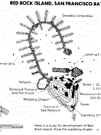 In 1964, they sold the island to David Glickman for $50,000, who planned a 20 story hotel. The City of Richmond opposed the plan, and invoked Hoover’s 1932 order to prevent development of the island. Glickman gave Mack Durning a quit-claim in 1965. Durning ended up returning the island to Glickman. 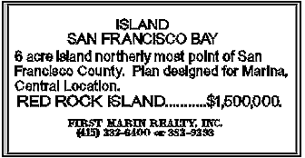 Except for the springtime return of nesting Canadian geese, seagulls and numerous other seabirds and harbor seals, Red Rock remains uninhabited. It's a favorite fishing and BASKing spot; and thanks to Hoover's order, the island may remain this way. Many thanks to the nice people at the Richmond Library Reference Desk and to the March 1980 issue of the Richmonder Magazine. 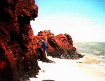 Red
Rock Red
Rock5.783 acres 1/2 mile south of the Richmond-San Rafael bridge summit is 172 feet water
60 feet deep |